

The Royal Palace in Nukuʻalofa, which is the capital of the Kingdom of Tonga. I took the photograph from our balcony as we slowly approached the wharf.
The maps below will give you an idea of the location of Tonga.


The pier as we came alongside. We could see the locals setting up stalls all along the pier.

As we came alongside a small band and a group of singers began singing songs of welcome.

Leaving the ship, we walked past a long row of stalls selling Tongan made items. The Tongans were polite and happy and did not try the hard sell – I don’t think this selling technique is in their nature.

Maureen & I in front of the Palace – the King no longer lives here, but the palace is still used for ceremonial purposes.
The Palace was dedicated in 1867as the royal residence of King George Tupou 1, and it is made from Kauru wood and has only required one major interior renovation, which took place in 2008.

Wherever we went we met happy friendly people, no wonder Tonga is also known as the Friendly Isles. Everyone smiled and wished us good morning or Malo e tau ma’u a pongipongini! which means good morning.

As we walked along the main street we came across a building flying the Union Flag of the UK so we looked closely and saw that it was High Commission of New Zealand, so I can only assume that the British High Commissioner was not in Tonga and the New Zealand High Commissioner was looking after British interests.
To clarify, amongst the members of the Commonwealth members do not send ambassadors to each other but High Commissioners.

Basilica of St Anthony of Padua
Just one of the churches that we saw in Tonga.

Nuku’alofa’s Free Church of Tonga.
The free Wesleyan church of Tonga was founded in 1885. In 1983 it was decided to build a Centennial Free Church of Tonga.
The foundation stone was laid in 1983 by his Majesty Tāufaʻāhau Tupou IV and the new church was opened in 1985.
Unfortunately, in 2018, the church was so badly damaged by Cyclone Gita it was forced to close.
For those who remember, the Tongan King who laid the foundation stone was the son of Queen Sālote Tupou III who attended the coronation of Queen Elizabeth in 1953.
Most British people have a soft spot for Queen Salote because when it rained during the drive to the coronation she refused to cover up. Her attitude was if the people can stand in the rain while watching the parade, I can ride in the rain and wave.
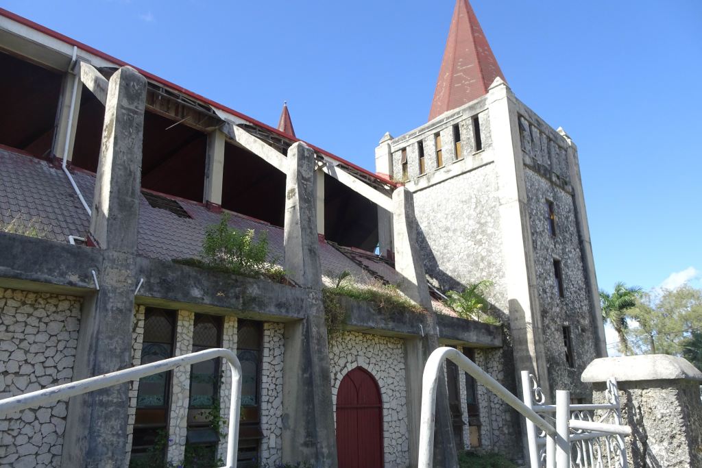
More damage could be seen down the side of the church.

Across from the church we could see The Royal Tombs, which were constructed in 1893, Mala’eKula (Red Ground) is the official name for the resting place King George Tupou 1, the modern father of Tonga. The area is part of the Royal Estate and the reason it is called the Red Ground was to represent the blood of Christ.
Queen Salote is also buried in the Royal Tombs.

We walked around the outside of the Palace and I put my hand through the railings to get the above picture, which also shows our cruise ship.

Maureen and the Coat of Arms for Tonga, which was designed in 1875 with the creation of the constitution.

The three swords represent the three dynasties or lines of the kings of Tonga, namely the Tuʻi Tonga, Tuʻi Haʻatakalaua and the current Tuʻi Kanokupolu). Tonga was united under King Siaosi Tupou I, who then orchestrated the formation of the first formal government and also the coat of arms. The dove with the olive branch symbolises the wish of God’s peace to reign in Tonga forever (the dove and olive branch are taken from the story of Noah and the Great Flood in the Bible).
The three stars symbolise the main island groups of Tonga, which are Tongatapu, Vavaʻu and Haʻapai. The Crown symbolises the ruling monarchy, the King of Tonga. The text on the scroll at the bottom reads Ko e ʻOtua mo Tonga ko hoku Tofiʻa in the Tongan language: ‘God and Tonga are my inheritance’.
Information taken from the internet.

We had walked all around the Palace and had hoped that we could walk along the waterfront area back to our starting point.
Unfortunately,the Palace grounds extended into the water so we had to retrace our steps, which was not far but it was a hot day.
It had been over thirty years since my last visit to Tonga and the only item that was ‘new’ for me was the wharf where our cruise ship berthed. The older but smaller pier remains could be seen. In town there were a few newer buildings but overall it was much the same as I remembered.
A couple of years ago I wrote about the history of Tonga and how they became Christian. If this is of interest the link below will take you to that blog.
If you have read the above older blog link, I never saw any old freighters just waiting and waiting, and the image of ‘Lord Jim’ did not appear, Tonga had moved on.


